The Megalithic Phenomenon and the Architecture of Anxiety

Megaliths of Northern Spain: The Architecture of Anxiety

By Nick Nutter | Published: 2026-09-19 | Updated: 2026-09-20

Visited 43 times

In northern Spain’s Cantabrian coast and Galicia, the transition from Mesolithic hunter-gatherers to Neolithic farmers was not a violent conquest, but a slow hybridisation. However, this merged agro-pastoral society soon faced a demographic wall. Trapped between the Atlantic Ocean and the impassable Cantabrian mountains, growing populations rapidly exhausted the land's carrying capacity. This severe spatial anxiety ignited a civil cold war over vanishing river valleys and highland pastures. To secure their shrinking territories, these desperate communities turned to the physics of stone, erecting dolmens, mámoas, and stelae, not as religious shrines, but as permanent, skyline-dominating boundary markers.

Megaliths of Northern Spain: The Architecture of Anxiety - Casola do Foxo
Casola do Foxo

The Geographic Trap

Moving south from the Aquitaine Gap, we cross the Bidasoa River. Here, the landscape changes dramatically. The northern coast of the Iberian Peninsula is known today as "Green Spain". But for the Neolithic populations of the fifth millennium BCE, this lushness was a trap.

The Cantabrian Mountains form a massive wall. They run parallel to the coast, often plunging directly into the Bay of Biscay. This leaves only a narrow, deeply forested coastal strip with occasional confined river valleys that only penetrate the hills for a few kilometres. There are no vast plains here. Arable land is incredibly scarce.

In our "Architecture of Anxiety" framework, this landscape is a pressure cooker. In Brittany, anxiety was driven by the rising sea pushing people inland. Here, anxiety was driven by the sheer physical reality of the topography. There was nowhere to expand. As archaeologists Jeffrey Fleisher and Neil Norman have argued, fear and social worry leave a literal, material imprint on the landscape. Here, that imprint was forged in stone (Fleisher & Norman, 2019).

The Clash of Cultures

Before the stones were raised, this narrow corridor was fiercely held. Entrenched Mesolithic hunter-gatherers dominated this coastline. With its forested hills, abundant freshwater, and rich estuaries, it was an absolute paradise for foragers. The most prominent were the makers of the "Asturian culture" (c. 9000 – 4000 BCE). These were not struggling nomads. They were highly specialised coastal foragers who had completely mastered their environment. Their signature survival tool was the pico asturiense (Asturian pick), a heavy, palm-sized quartzite cobble knapped into a robust point, perfectly designed for prying limpets and oysters from the rocky shoreline.

For millennia, they harvested the Atlantic, piling up massive concheros (shell middens) in the mouths of limestone caves. Combined with the deer and boar hunted in the dense oak forests, these estuaries provided an immense caloric surplus. These indigenous populations thrived. Because their environment was so predictably rich, they had absolutely no need for the back-breaking labour of agriculture.

Unlike the famous hunter-gatherers of the Tagus Valley in Portugal, the northern foragers kept their dead hidden. In Portugal, Mesolithic tribes buried hundreds of bodies directly into their massive shell mounds, already creating early, visible cemeteries. But human remains in Cantabrian and Asturian middens are incredibly rare.

When the northern foragers did bury their dead, they retreated into the dark. At the Los Canes cave in Asturias, archaeologists found three individuals placed in simple pits deep underground (Arias & Garralda, 1996). They were completely invisible to the outside world. The indigenous tribes did not yet need to use their ancestors as territorial flags. In their minds, they already owned the landscape. Recent accelerator mass spectrometry (AMS) testing, a highly precise method of carbon dating, has given us a remarkably tight window. The oldest burial dates to between 6052 and 5917 BCE. The most recent burial, belonging to a woman who lived to around sixty years of age, dates to between 5286 and 5050 BCE.

The Civil Cold War: Genes, Pollen, and Stone

This makes the arrival of megaliths a thousand years later even more startling. The transition was not driven by foreign missionaries, nor was it the sudden invention of isolated foragers. Instead, it was the architectural product of a hybridised society.

The archaeological record provides the smoking gun for this merger. Stable isotope analysis, a scientific method of testing human bone to reveal ancient dietary signatures, shows a gradual, seamless shift in the Cantabrian caves. The heavy marine diet of the Mesolithic foragers slowly gave way to a terrestrial diet based on domesticated plants and livestock (Arias, 2007). They did not conquer one another; they merged into a single agro-pastoral population.

But this assimilation did not solve the anxiety, rather it amplified it. The adoption of farming and herding triggered a crisis of carrying capacity (the maximum population an environment can sustain). As this newly hybridised population grew, they had to contend with the topographical nature of the Cantabrian coast. Pastoralism required exclusive access to the high summer pastures, while agriculture demanded permanent control of the rare, flat river valleys.

We can actually see this panic in the environmental record. Palynology (ancient pollen analysis) extracted from upland peat bogs in Asturias and Galicia shows a sudden spike in charcoal particles and grass pollen right around 4000 BCE. The dense primeval forests were being burned down to artificially expand the brañas (mountain pastures) for cattle (Muñoz Sobrino et al., 2007). The landscape was filling up, and the farmers were running out of room.

The conflict was no longer a clash of cultures. It was a civil cold war over finite space. As the valleys became crowded, these communities fractured into competing lineages, fighting their own neighbours for survival. The archaeological record from nearby mass graves reveals that skirmishes and lethal raids over territory became a brutal reality. Landscape archaeologists have used spatial analysis to map these megaliths, proving they were not built randomly. Felipe Criado Boado pioneered the landscape archaeology of northwestern Spain, demonstrating how prehistoric monuments were intentionally positioned as visual controls over territory, paths, and economic resources (Criado Boado, 1989).

The invisible, subterranean ancestors of the Mesolithic era were no longer enough to hold contested ground. To secure these vanishing resources, each lineage metaphorically dragged their dead out of the caves and built massive, skyline-dominating stone tombs. The megalith became the ultimate boundary marker, a permanent "Keep Out" sign aimed directly at the clan in the next valley.

Megaliths of Northern Spain: The Architecture of Anxiety - Simple cist beneath a mámoas at Monte Areo Necropolis
Simple cist beneath a mámoas at Monte Areo Necropolis

Stone Turnstiles and Visual Dominance

The megalithic architecture of Northern Spain is dictated by this topographical anxiety. Rather than building sprawling alignments like Carnac, these builders erected precise, strategic markers. They built dolmens (single-chamber tombs) and mámoas (earthen mounds or tumuli) in specific choke points to control movement and resources. As Colin Renfrew famously argued, megalithic tombs functioned essentially as territorial markers for segmentary societies, staking out the land claims of competing lineage groups as population densities rose (Renfrew, 1976).

The Aralar Range Dolmens (Basque Country/Navarre)

High in the misty mountains separating the coast from the interior, dozens of these monuments dot the landscape. Built between 3200 and 1500 BCE (from the Late Neolithic to the Early Bronze Age), they are architecturally austere. These are not sprawling passage graves, they are simple dolmens. Most consist of a small, enclosed rectangular or polygonal stone box, a megalithic cist, originally covered by a modest earthen mound. They sit directly on traditional migratory routes for livestock, acting as permanent, economical sentinels over the high brañas (Apellániz, 1973).

The Upland Sentinels (Asturias)

As populations were squeezed out of the coastal lowlands, they pushed into the rugged interior. The dolmens of Merillés (Tineo) and Pradías (Ibias) in western Asturias sit in difficult, mountainous zones, locking down remote economic lifelines. Generally constructed between 3500 and 3000 BCE during the Middle to Late Neolithic, these monuments represent a shift from communal burial to tactical demarcation. Architecturally, they are classified as simple dolmens or short-corridor passage graves, typically consisting of four to six vertical orthostats supporting a massive, single flat capstone, all originally enclosed within a circular stone cairn or túmulo (de Blas Cortina, 1998).

The Coastal Necropolises (Asturias & Cantabria)

On the coastal plateaus and raised terraces overlooking the Bay of Biscay, sites like the Monte Areo Necropolis (holding over thirty mámoas), the Sierra Plana de la Borbolla (Llanes), and the Sierra de Penouta (Boal) dominate the visual landscape. At Monte Areo, specific clusters like the dolmens of Cierru Los Llanos and San Pablo illustrate this domination. Constructed primarily between 4000 and 3000 BCE during the Early to Middle Neolithic, these sprawling necropolises represent the frontline of territorial defence. Architecturally, they consist predominantly of mámoas, low, circular mounds constructed from earth and loose stone that encase simple dolerite or sandstone cists and short-corridor chambers. Positioned deliberately on prominent ridge lines and high coastal plateaus, these ridge-top monuments were engineered to loom over the narrow coastal strip and marine access points below, functioning as high-visibility boundary markers (Miguel López, 2004).

Megaliths of Northern Spain: The Architecture of Anxiety - Ídolo de Peña Tú
Ídolo de Peña Tú

The Warrior Cult

Sometimes, territorial anxiety required a face.

At the Ídolo de Peña Tú (Llanes, Asturias), we see a massive rock outcrop painted and engraved with a stylised human figure wielding a dagger. This is not just decorative art. It is an armed guard (Bueno Ramírez, 1990). The idol serves as a permanent, intimidating warning to outsiders entering the valley, representing the anthropomorphisation of the territorial marker, the "Big Man" etched directly into the mountain.

Trade, Transmission, and the Shared Language of Stone

Cultural similarity across separated regions is entirely expected, but it requires active, tangible contact to occur. We have already demonstrated that there was no direct cultural or chronological continuity linking the megalithic explosion of Brittany to northern Spain. The idea of a unified "Atlantic Europe" bound by a shared monolithic culture is an archaeological illusion. However, localised maritime and riverine trade networks did exist between Asturias, Galicia, Portugal, and southern Spain. Contact happened in specific bursts, and when it did, ideas, luxury goods, and artistic motifs moved along those routes.

The phenomenon of the "warrior stelae" provides a good example of this networked contact. While the Ídolo de Peña Tú in Asturias stands as an early, isolated sentinel brandishing its dagger during the Neolithic transition, the tradition of carving armed, anthropomorphic figures evolved and proliferated centuries later across Portugal and southern Spain. Primitiva Bueno Ramírez has written extensively on how rock art, stelae, and symbolic monuments acted as social and ideological boundary markers during periods of heightened Iberian competition (Bueno Ramírez, 1990).

Archaeologists trace an ideological thread linking these regional expressions. A warlord or emerging elite in the Tagus basin or Extremadura communicated authority through the same iconography of a carved sword, shield, and spear. When northern communities maintained trade contact with these southern centres, they accessed a shared visual vocabulary of power.

The existence of this trade network demolishes the old idea that isolated pockets invented these symbols in a total vacuum. The Cantabrian pastoralists, the Portuguese coastal communities, and the southern elites were in communication through coastal cabotage and river roads. Yet, how they used that shared iconography depended entirely on their local environment. When a southern Iberian group faced social stratification and rising competition over rich agricultural plains, they adapted the warrior stela to broadcast individual warlord dominance. When a northern Cantabrian group faced topographically bottled claustrophobia, they adapted the motif into an aggressive boundary marker like Peña Tú.

Recognising this network of contact is an integral part of our thesis. Trade provided the artistic templates, but local anxiety pulled the trigger. Communities across Asturias, Galicia, Portugal, and Andalucia [Andalusia] may have shared a material language through trade contact, but they deployed it as a weapon to match their specific, localised fears. We will trace this evolution further as we move south into the river valleys of Portugal and the baking plains of Andalucia, where the architecture of anxiety shifts once again to meet a very different kind of crisis.

Sacred through the Ages

The Dolmen de Santa Cruz (Cangas de Onís, Asturias) was erected on a strategic river crossing. It was decorated with complex red-painted megalithic art. The site held such spiritual and territorial weight over the valley that centuries later, a Christian church was simply built on top of the ancient mound.

Megaliths of Northern Spain: The Architecture of Anxiety - Casiña da Moura
Casiña da Moura

The Upland Valley Choke Points (Ourense, Galicia)

Not all the pressure was on the coast; as populations expanded, the rugged interior mountains became equally contested. In the harsh terrain of the Xurés range near the modern Portuguese border, flat, arable land is almost non-existent. The only viable lifelines for agro-pastoralists were the narrow river valleys.

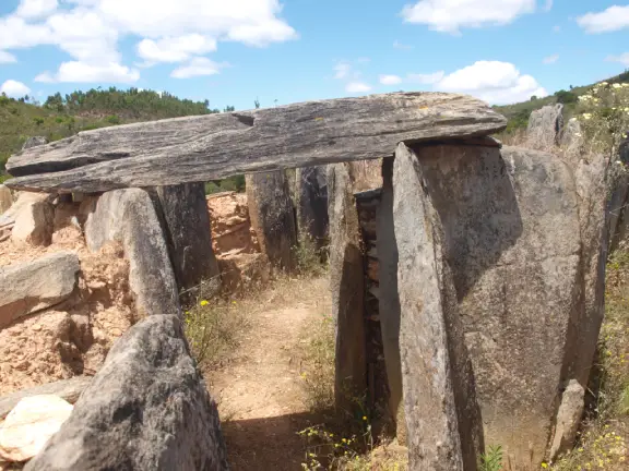
The megalithic complex at Maus de Salas, including the dolmens of Casiña da Moura and Casola do Foxo, illustrates this interior anxiety. Built along the fertile floor of the Salas river valley, these monuments acted as physical locks on the landscape's most valuable real estate. They demonstrate the biological limits of the landscape. While architecturally striking, they are smaller than the coastal giants. Built by localised upland clans, their size was strictly governed by the limited carrying capacity of the mountain valley they were built to defend.

Megaliths of Northern Spain: The Architecture of Anxiety - Dolmen Dombate
Dolmen Dombate

The Galician Climax

As we move west into Galicia, the coastal strip widens slightly, but the anxiety only intensifies. The land physically runs out at the Atlantic Ocean. This is Finisterre, the end of the earth, where territorial marking reaches a colossal scale.

Dolmen of Axeitos

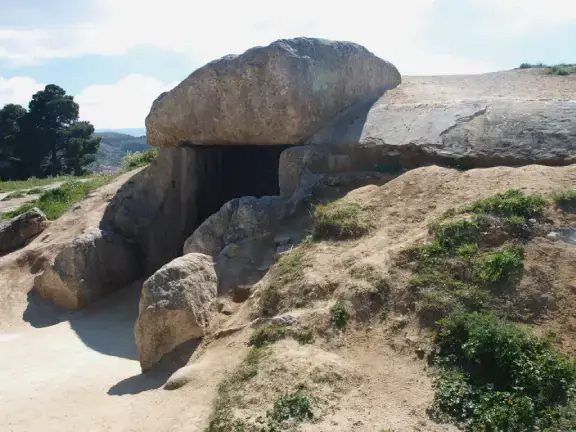
Located on the Barbanza Peninsula near the Galician coast, Axeitos is a raw, brutal statement of ownership. Seven massive orthostats support a single, enormous capstone. Archaeologically dated to between 4000 and 3600 BCE, it spans the early to middle Neolithic period, marking a time of rising territorial stress as agro-pastoral communities locked down the landscape.

Dolmen of Dombate

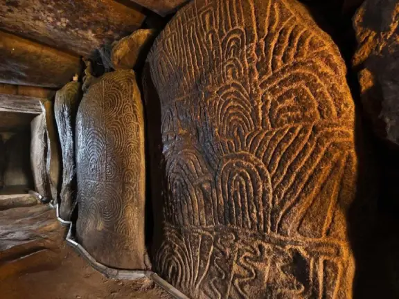
Often called the "Cathedral of Galician Megalithism," Dombate encapsulates multi-generational stress (Bello Diéguez, 1995). First built around 3900 BCE as a small stone chamber, the local population returned around 3000 BCE as pressure peaked. They buried the old monument and erected a massive new passage grave over it, covering it with a colossal mámoa 24 metres in diameter. The dense red and black apotropaic art inside served as a spiritual lock on the tomb (Shee Twohig, 1981).

The Saturated Corridors of the Costa da Morte

Moving south and west of Dombate into the coastal hinterlands, we find a landscape scattered with stone. Within a tight geographical web, massive elite passage graves like Pedra Cuberta, Pedra da Arca, and Mina de Parxubeira sit shoulder-to-shoulder with a dense network of smaller monuments: Pedra Vixía, A Fornella dos Mouros, Mina de Recesindes, Arquiña de Vilaseco, Pedra da Lebre, Arca da Piosa, Casota de Freans, and Arca de Rabos. This density reveals a fractured, highly competitive territory. Every pocket of arable land, every stream, and every lineage required its own distinct stone flag, with the size of each tomb strictly dictated by the resources that specific clan controlled.

Islands and Parliaments

Topography was not the only enemy. Environmental and social pressures demanded alternative architectural solutions.

Mámoas of Guidoiro Areoso (A Illa de Arousa, Galicia)

On this tiny islet in the middle of the Ría de Arousa estuary, we find a dense cluster of burial mounds. Just like in Brittany, rising Atlantic sea levels were swallowing the land. The islanders built massive mounds to anchor their shrinking world, frantically staking claims to a landscape that was drowning as they watched (Rey García, 2011).

A Mourela (As Pontes, Galicia)

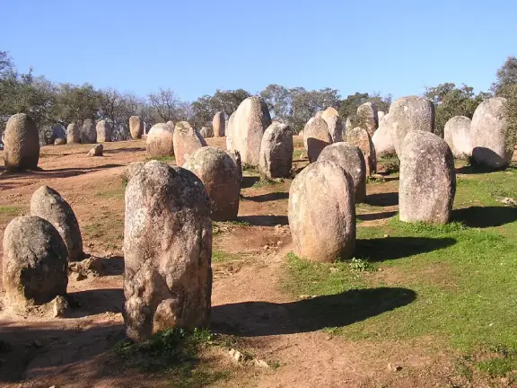
To manage the immense social friction they were experiencing, the Galician tribes also built "Parliaments of the Living." The rare stone circles (círculos líticos da Mourela) in northern A Coruña province served as enclosed, sanctified spaces designed for stressed communities to gather, negotiate territory, and resolve disputes without resorting to warfare.

The Edge of the World

The megaliths of the northern Iberian coast dismantle an old myth. The "Megalithic Missionary" never existed. Nobody sailed from Brittany across the treacherous Bay of Biscay to teach the Galicians how to build Dombate.

Instead, the indigenous populations reached their own breaking point in their own time. Trapped between the tempestuous Atlantic and the impassable Cantabrian mountains, they faced a demographic wall. Stripped of space, threatened by rising seas, and forced into competition over vanishing river valleys, they turned to the physics of stone. They anchored their claims in a landscape that had no room left to give.

This severe scarcity of arable land dictated not just the location of the monuments, but their scale. The carrying capacity of the rugged Cantabrian coast was vastly lower than the plains of Brittany. Populations per hectare were smaller. Ultimately, the number of people a valley could feed determined the maximum weight of stone a clan could heave across the landscape. This biological limit explains the heavy reliance on earthen mámoas and simple stone cists, and the complete absence of colossal Carnac-style alignments. The architecture was born of anxiety, but its size was strictly bounded by calories.

References and Further Reading

  • Apellániz, J.M. (1973). Los sepulcros megalíticos en el País Vasco. Munibe (Suplemento 1).
  • Arias, P. & Garralda, M. D. (1996). 'Mesolithic burials in Los Canes cave (Asturias, Spain)', Human Evolution, 11, pp. 129–138.
  • Arias, P. (1999). 'The origins of the Neolithic along the Atlantic coast of continental Europe: a survey', Journal of World Prehistory, 13(4), pp. 403–464.
  • Arias, P. et al. (2005). El megalitismo en la rasa costera cantábrica. Ediciones Trea.
  • Arias, P. (2007). 'Neolithic and Paleolithic concepts of nature: a view from the Cantabrian region', in Going Over: The Mesolithic-Neolithic Transition in North-West Europe. Oxford: Oxford University Press, pp. 433–451.
  • Bello Diéguez, J. M. (1995). 'El dolmen de Dombate (Cabana, A Coruña)', Trabajos de Prehistoria, 52(1), pp. 153–166.
  • Bueno Ramírez, P. (1990). 'Megalitismo, estatuas-menhir y estelas decoradas en la Península Ibérica', Trabajos de Prehistoria, 47, pp. 95–143.
  • Criado Boado, F. (1989). 'We, the post-megalithic people...', in The Meanings of Things: Material Culture and Symbolic Expression. London: Unwin Hyman, pp. 79–89.
  • de Blas Cortina, M.A. (1998). 'El megalitismo en Asturias: estado de la cuestión', in Actas del II Congreso de Arqueología de la Península Ibérica, pp. 115–130.
  • Fábregas Valcarce, R. (2011). 'El megalitismo gallego a los cien años del trabajo de los Leisner', Munibe Antropologia-Arkeologia, 62, pp. 195–216.
  • Fleisher, J. & Norman, N. (eds.) (2019). The Archaeology of Anxiety: The Materiality of Anxiousness, Worry, and Fear. New York: Springer.
  • Miguel López, C. (2004). 'La necrópolis tumular de Monte Areo (Carreño-Gijón, Asturias)', Zephyrus, 57, pp. 147–165.
  • Muñoz Sobrino, C., Ramil-Rego, P. & Gómez-Orellana, L. (2007). 'Late Würm and early Holocene in the mountains of northwest Iberia: biostratigraphy, chronology and tree line dynamics', Vegetation History and Archaeobotany, 16(3), pp. 223–240.
  • Renfrew, C. (1976). 'Megaliths, Territories and Populations', in De Laet, S.J. (ed.) Acculturation and Continuity in Atlantic Europe. Bruges: De Tempel, pp. 198–220.
  • Rey García, J. M. (2011). 'Guidoiro Areoso (A Illa de Arousa, Pontevedra): un islote arqueológico en peligro', Cuadernos de Estudios Gallegos, 58(124), pp. 29–51.
  • Shee Twohig, E. (1981). The Megalithic Art of Western Europe. Oxford: Clarendon Press.
Legacy Reloaded: A dev, an AI, and the relentless pursuit of 100

Enjoying this clean, uncluttered read?

You are currently browsing the result of a massive technical overhaul. My new book, Legacy Reloaded: A dev, an AI, and the relentless pursuit of 100, chronicles the journey of transforming an aging legacy website into a modern, lightning-fast platform that hits the perfect 90+, 100, 100, 100, 3/3 Lighthouse metrics. It’s a story of collaboration between developer and AI, and the stubborn pursuit of technical perfection.

Read the Story

You have finished reading chapter 3

More articles in the The Megalithic Phenomenon and the Architecture of Anxiety series: